Technical Specifications
120,000m²
Max SLAM Coverage
±5mm
Stopping Precision
8types
Drive Types Supported
Key Features
5 featuresNon-Stop Localization
Adaptive switching maintains navigation even at 20% map match rate. No map re-creation needed on environment changes.
Learn more ↓Single SW for 7 Drive Types
Covers DD, Quad, Single, Mecanum, FRDD, Ackermann, 4WD with parameter switching only. No separate SW development per platform.
Learn more ↓6 Built-in Docking Methods
SLAM, QR, V-Marker, ArUco, Intensity, and AI Vision docking supported on a single platform.
Learn more ↓Large-Scale Scalability
Covers up to 120,000m² at 1mm resolution. Ready for large-scale manufacturing and logistics sites.
Learn more ↓1-Day On-Site Setup
GUI-based tool: 0.5 day setup + 0.5 day live operation. Dramatically shortens PoC-to-production transition.
Learn more ↓2D/3D SLAM and Localization
NaviFra's high-precision SLAM technology supports both 2D and 3D. In indoor and outdoor environments with dynamic obstacles, NaviFra's own patented technology models the environment quickly and accurately and performs robust localization.
Large-Area SLAM Based on 2D LiDAR
Large-Area SLAM Based on 2D LiDAR
- Delivers optimized maps with over 90% map consistency, built on a robust CPU-only SLAM algorithm, even in large spaces (120,000 m²) with few features
- Provides post-mapping update functions such as automatic map alignment, noise removal, partial mapping, and map merging, enabling a flexible response when equipment is added to or removed from the environment
- Map building from log data playback
- We implemented the entire pipeline ourselves, from scan matching (front-end) to pose graph optimization (back-end). With no black boxes and a full understanding of the whole system, we can modify and optimize it to fit site requirements.
3D LiDAR SLAM — Same Results on Our Own Sites and Public Benchmarks
On the left is large-area outdoor data we captured ourselves; on the right is a public benchmark dataset — both processed with the same algorithm.
- Building a map and finding your own position on that map are different problems. The environment is mapped once with 3D LiDAR, and all later runs localize on that map. Both stages must share the same representation for the map to be reused again and again.
- In-house data — a large outdoor environment mixing structures of different heights, such as buildings, trees, and slopes, is mapped in a single pass. Even spaces that a flat map cannot distinguish are represented.
- Public benchmark data — multiple sequences captured at different times were each localized on the same map; the right side shows one segment. It displays the onboard camera, a local map within a 60 m radius of the vehicle, and the estimated position on the full map. Even as lighting and traffic change and sections where the sky is blocked, such as tunnels, are mixed in, the estimated position stays on the same path.
- An algorithm that only works on its own data is useless in the field. Getting the same results on a public dataset — where we chose neither the capture environment nor the sensor configuration — is the evidence that it can be deployed as-is at new sites.
In-house data · Large-area outdoor mapping
Public benchmark data · Localization with the same algorithm
Lidar Odometry
Lidar Odometry
- Automatically detects drops in localization confidence and performs local localization based on LiDAR Odometry, preventing position loss and ensuring continuous positioning
- Provides APIs for integrating various external positioning sensors such as barcodes, QR codes, and cameras, flexibly extending absolute position correction and position recovery
- Corrects its own position through robust LiDAR matching, even during momentary slips caused by small obstacles such as water, oil, or bolts
8 Drive Type Support
AMR drive types vary depending on robot purpose and hardware design. Navi-Core has built-in kinematic models for 8 drive types, allowing drive type switching through parameter settings alone. This means robot manufacturers can immediately apply Navi-Core to new drive type robots without any SW customization on the Navi-Core side.
NaviFra's Diverse Motion Capabilities
Dual/Quad steering drive enables non-stop spin turns. It prevents the floor damage caused by in-place rotation and shortens process time.
6 Docking Method Support
The docking station’s coordinates are registered in the map. The robot navigates autonomously toward them; up to this point it is no different from normal driving.
Selectable docking methods are provided according to site environment and customer requirements. Each method differs in recognition principle and application conditions, and it is also possible to simultaneously mount multiple methods on a single robot for automatic selection per docking target. Maximum docking speed is 0.5m/sec.
Obstacle Detection & Avoidance
Industrial aisles are not a space robots have to themselves. Forklifts come head-on, workers pass alongside, and other AMRs cross paths. Lane-based avoidance is a design that chooses predictability over autonomy.
Obstacle Detection
Obstacle Avoidance
Industrial aisles are not a space robots have to themselves. Forklifts come head-on, many workers are present, and other AMRs cross paths. NaviFra's lane-based avoidance is a design that chooses predictability over autonomy. You know in advance when it will avoid, and to which side.
| Free-space avoidance | Navifra lane avoidance | |
|---|---|---|
| Avoidance paths | Generated per cycle — effectively unbounded | Finite set declared on the map |
| Direction | Unknowable until the robot arrives | Fixed in advance |
| Lateral offset | Differs on every run | Fixed by lane position |
| Fleet control | Cannot reserve the occupied area ahead of time | Reserved and adjusted per lane |
| Post-incident review | Hard to reproduce or explain | Which lane, and why, is logged |
| Aisle usage | Must leave room for the widest swing | Only the declared lane width |
Dozens of candidate paths are generated every control cycle and the cheapest wins. Left and right costs usually differ by under 1%, so sensor noise alone flips the ranking — the same aisle and the same obstacle get a left pass one time and a right pass the next.
A service robot runs through free space, not on links. The global path is a single line to the destination, and the full aisle width is drivable at any time.
Avoidance lanes are declared on the map, segment by segment. When an obstacle appears the robot moves into whichever declared lane is passable, clears the obstacle, and returns to its link. Because avoidance stays bound to the link, traffic control and path planning are unaffected.
The driving space is defined as nodes and links. The robot runs only on these links, not through arbitrary free space, so where it can go is already fixed at the map stage.
Navi-Core Ecosystem
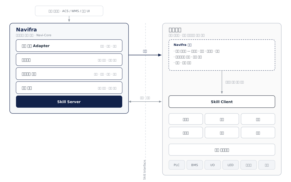
With open interfaces and templates, partners control their own equipment directly
- NaviFra handles the common autonomous navigation foundation — positioning, path planning, avoidance, docking — while partners handle onboard equipment control such as lifts, charging, and indicator lights. The two domains are connected through a single open Skill Interface.
- The company that built a robot already knows its equipment's characteristics and edge cases. Most of the time — and most misunderstandings — are lost in the process of turning that knowledge into documents and handing it over.
- We provide implementation templates, interface specifications and integration documentation, and development and validation tools. Partners can implement without opening the Navi-Core source, and their equipment control know-how stays with them.
- Partners add new vehicle types and equipment at their own pace. One company's headcount no longer sets the ceiling for an entire industry.
- The more companies use the same interface, the more implementations are reused, and new projects start not from a blank page but from proven results.
Compatibility & Integration
A compact add-on design mounts directly on a wide range of robot platforms. Standard interfaces make it easy to connect with your existing infrastructure.
Contact Sales about Navi-Core
Analyze your site with our experts and design the right solution. We support you through every step, from consultation to on-site installation.